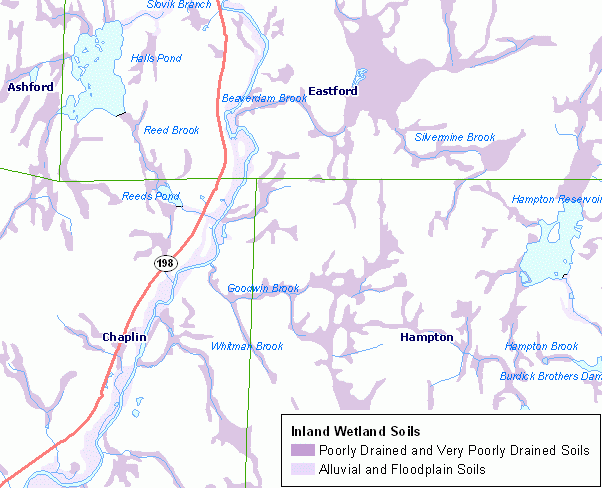
Inland Wetland Soils provide the general location of soil map units in Connecticut that are defined as Inland Wetlands and may be subject to regulation. The Connecticut Inland Wetlands and Watercourses Act, Connecticut General Statutes Section 22a-38, defines wetland soils to include, "Any of the soil types designated as poorly drained, very poorly drained, alluvial, and floodplain by the National Cooperative Soil Survey, as may be amended from time to time, of the Natural Resources Conservation Service of the United States Department of Agriculture". For additional documentation including a description of the map legend for Inland Wetland Soils, refer to the CT ECO Complete Resource Guide for Inland Wetland Soils.
All soil information included in the CT ECO maps and map viewers is from the Natural Resources Conservation Service (NRCS) Web Soil Survey (WSS), which is based on information originally published on the set of Soil Survey quarter quadrangle maps that cover Connecticut.
The purpose of this information is to locate areas of inland wetland soils for general planning purposes. It may be used by municipalities’ land use commissions and town planners, homeowners, engineers, farmers, and others to assist them in planning land use activities related to inland wetlands and adjacent upland areas.
This information is to be used as a guide for general planning purposes only. On site investigation is necessary to determine the presence or absence of Inland Wetland soils in a particular area. This is public information and may be interpreted by organizations, agencies, units of government, or others based on needs; however, they are responsible for the appropriate application. Federal, State, or local regulatory bodies are not to reassign to the Natural Resources Conservation Service any authority for the decisions that they make. The Natural Resources Conservation Service will not perform any evaluations of these maps for purposes related solely to State or local regulatory programs. Please see the CT ECO Complete Resource Guide for Inland Wetland Soils for additional use limitations.