Includes Local Drainage Basin and Elevation Contour information for Connecticut.
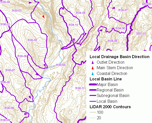
A standardized mapping of natural drainage basins in Connecticut was completed in 1981 by the Connecticut Department of Environmental Protection (DEP). This drainage basin system divided Connecticut into 8 major basins, 45 regional basins, 337 subregional basins, 2,898 local basins, and 7,067 small drainage basin areas. The statewide mapping of natural drainage basins established a hierarchical system of basins based on drainage area size with large major basins subdivided into regional basins, regional basins subdivided into subregional basins, subregional basins subdivided into local basins, and local basins subdivided into smaller and more numerous drainage basin areas. This map of Natural Drainage Basins includes major, regional, subregional and local drainage basin areas, labeling each local drainage basin area with its corresponding 7-digit local drainage basin number. Local drainage basins are subdivided into smaller drainage basin areas, which are not shown on this map.
Shown on this map are small arrows that depict the general direction of surface water flow within individual local drainage basins. Particular emphasis is given to directional arrows near the location of local drainage basin outlets where one basin drains into another. These and other arrows along stretches of local drainage basin main stem basins and in coastal basins that drain into Long Island Sound are intended to aid in visualizing the network of local drainage basins in Connecticut. These Local Drainage Basin Direction arrows are classified into three types - Outlet Direction, Main Stem Direction and Coastal Direction. Outlet Direction arrows represent general direction of a river or stream at the local drainage basin outlet. Main Stem Direction arrows represent the stream direction of main stem local basins. The local drainage basin numbers for Main Stem local basins end with "-00", such as 4302-00. Coastal Direction arrows indicate the very general direction of surface water within local coastal basins that drain into Long Island Sound.
Elevation Contours includes 2, 10, 20, 50, and 100 ft elevation contour lines for Connecticut. Note, the contour interval shown depends on the current scale of the map with smaller intervals displayed when zoomed in at larger and more detailed scales. This information was derived from Connecticut’s 2000 statewide LiDAR dataset by the University of Connecticut, College of Agriculture and Natural Resources, Department of Natural Resources and the Environment. These data are a Beta product intended for research and demonstration purposes.
A drainage basin is an area of land where water from rain or snow melt drains downhill into a body of water such as a river, lake, wetland or ocean. The drainage basin includes both the streams and rivers that convey the water as well as the land surface from which water drains into those channels. Used as the basis for DEP drainage basin mapping, a natural drainage basin is one in which the outlet point is a natural occurring feature. These outlet points occur at stream confluences, stream outfalls into waterbodies, and impoundments.
The hierarchical system of drainage basin delineation and numbering, as implemented by DEP, allow for the association of the physical resources to the naturally occuring drainage system that covers Connecticut. This information can be used to determine where rainfall naturally flows over the land and downstream to a particular watercourse. It can be used to identify the upstream contributing watershed for a point along a river, stream, reservoir, lake, or pond. And for cataloging purposes, a drainage basin identifier can be associated with any location on land or water in Connecticut.
The Elevation Contour information denotes elevation above sea level. From these contours a general sense of the lie of the land, terrain or relief can be determined. Terrain affects surface water flow. The direction of a stream can be determined by taking note of the shape of contour lines as they cross a stream. Contour lines are often V shaped where they cross a stream. Commonly known as the rule of V's, the V in the contour line always points upstream. Additionally, the closer contour lines are to one another the steeper the slope.
Drainage basin boundaries were manually delineated by interpreting the 10 foot contour lines and hydrography features shown on USGS 1:24,000-scale topographic quadrangle maps. The horizontal positional accuracy of this information is consistent with other 1:24,000-scale hydrography related data such as Connecticut Hydrography, Connecticut Waterbody, Connecticut Named Waterbody and Connecticut Surface Water Quality Classification. Only limited field checking was conducted to verify the location of these basin boundaries. Basin boundaries may not be accurate in areas that have been diked for flood control, upland wetland and reservoirs having outlets into two basins, and areas where topographic mapping is not up to date, is inaccurate, or is not detailed enough to adequately define local drainage. Residential and commercial development, highway construction, and other changes to the landscape may have resulted in local modifications to the natural drainage pattern since the time these basin boundaries were delineated.
The Elevation Contour information is known to be incorrect in some areas. Please refer to the Elevation Contours CT ECO Basic Data Guide for an explanation of this use limitation.
Local Drainage Basin
Elevation Contours
This CT ECO data guide describes a thematic map that is no longer available online from CT ECO. A more recent Connecticut Natural Drainage Basins with Elevation Contours CT ECO Guide describes a similar map currently online that includes slightly different Connecticut Contours 2000 data.