Includes Local Drainage Basin and Elevation Contour information for Connecticut.
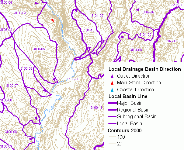
A standardized mapping of natural drainage basins in Connecticut was completed in 1981 by the Connecticut Department of Environmental Protection (DEP). This drainage basin system divided Connecticut into 8 major basins, 45 regional basins, 337 subregional basins, 2,898 local basins, and 7,067 small drainage basin areas. The statewide mapping of natural drainage basins established a hierarchical system of basins based on drainage area size with large major basins subdivided into regional basins, regional basins subdivided into subregional basins, subregional basins subdivided into local basins, and local basins subdivided into smaller and more numerous drainage basin areas. This map of Natural Drainage Basins includes major, regional, subregional and local drainage basin areas, labeling each local drainage basin area with its corresponding 7-digit local drainage basin number. Local drainage basins are subdivided into smaller drainage basin areas, which are not shown on this map.
Each drainage basin in Connecticut is assigned a full basin number (BASIN_NO) that uniquely identifies each basin. There are 7,031 unique basin numbers, and length of the number can be up to 13 characters long, depending on stream order of the basin. Examples include 6000-00-1+*, 4300-00-1+L1, and 6002-00-2-R1. The first digit (column 1) designates the major basin, the first two digits (columns 1-2) designate the regional basin, the first 4 digits (columns 1-4) designate the subregional basin, and the first seven digits (columns 1-7) designate the local basin. The basin number includes a few codes at the end. An asterisk sign (*) denotes a headwater basin containing a delineated impoundment into which a delineated drainage basin outlets. The letter L (for lake) denotes a reach-impoundment identifier for an impoundment basin and is followed by the reach-impoundment number. The letter R (for reach) denotes a reach-impoundment identifier for a stream reach basin and is followed by the reach-impoundment number. For a description of the system of drainage basin numbers and to identify either all upstream basins draining to a particular location or all downstream basins flowing from a particular location, refer to the Gazetteer of Drainage Areas of Connecticut , Nosal, 1977, CT DEP Water Resources Bulletin 15, for the hydrologic sequence, headwater to outfall, of drainage basins.
Also shown on this map are small colored arrows that depict the general direction of surface water flow within individual local drainage basins. Particular emphasis is given to directional arrows near the location of local drainage basin outlets where one basin drains into another. These and other arrows along stretches of local drainage basin main stem basins and in coastal basins that drain into Long Island Sound are intended to aid in visualizing the network of local drainage basins in Connecticut. These Local Drainage Basin Direction arrows are classified into three types - Outlet Direction, Main Stem Direction and Coastal Direction. Outlet Direction arrows represent general direction of a river or stream at the local drainage basin outlet. Main Stem Direction arrows represent the stream direction of main stem local basins. The local drainage basin numbers for Main Stem local basins end with "-00", such as 4302-00. Coastal Direction arrows indicate the very general direction of surface water within local coastal basins that drain into Long Island Sound.
Elevation contours shown on this map are Connecticut Contours 2000 data, which is a statewide dataset of 2, 5, 10, 20, 50, and 100 ft contour lines for Connecticut based on elevation information for the year 2000. Note, the actual contour interval shown depends on the scale of the map, with smaller intervals displayed when zoomed in and larger intervals displayed when zoomed out at less detailed scales. This information replaces the Lidar 2000 Contour data previously shown on this map.
A drainage basin is an area of land where water from rain or snow melt drains downhill into a body of water such as a river, lake, wetland or ocean. The drainage basin includes both the streams and rivers that convey the water as well as the land surface from which water drains into those channels. Used as the basis for DEP drainage basin mapping, a natural drainage basin is one in which the outlet point is a natural occurring feature. These outlet points occur at stream confluences, stream outfalls into waterbodies, and impoundments.
The hierarchical system of drainage basin delineation and numbering, as implemented by DEP, allow for the association of the physical resources to the naturally occuring drainage system that covers Connecticut. This information can be used to determine where rainfall naturally flows over the land and downstream to a particular watercourse. It can be used to identify the upstream contributing watershed for a point along a river, stream, reservoir, lake, or pond. And for cataloging purposes, a drainage basin identifier can be associated with any location on land or water in Connecticut.
The Elevation Contour information describes elevation above sea level. With this information, a general sense of the lay of the land, terrain or relief can be ascertained. Gentle sloops are characterized by widely spaced contour lines. Steep slopes are represented by closely spaced contour lines. Contour lines that cross streams flowing through valleys of noticeable relief will form a V-shaped deflection with the apex of the V pointing upstream. This is commonly known as the rule of V's.
Drainage basin boundaries were manually delineated by interpreting the 10 foot contour lines and hydrography features shown on USGS 1:24,000-scale topographic quadrangle maps. The horizontal positional accuracy of this information is consistent with other 1:24,000-scale hydrography related data such as Connecticut Hydrography, Connecticut Waterbody, Connecticut Named Waterbody and Connecticut Surface Water Quality Classification. Only limited field checking was conducted to verify the location of these basin boundaries. Basin boundaries may not be accurate in areas that have been diked for flood control, upland wetland and reservoirs having outlets into two basins, and areas where topographic mapping is not up to date, is inaccurate, or is not detailed enough to adequately define local drainage. Residential and commercial development, highway construction, and other changes to the landscape may have resulted in local modifications to the natural drainage pattern since the time these basin boundaries were delineated.
The Elevation Contour information is known to be incorrect in some areas and is only suitable for general planning and informational purposes. It is not intended for exact determinations of floodplain or other similar elevations where a detailed survey is normally required, for example. It is useful in obtaining a general understanding of the elevation for a particular area, but not suitable for detailed engineering, building and design purposes. Refer to the Connecticut Contours 2000 CT ECO Basic Data Guide for additional information on the use limitations of this information.
Local Drainage Basin
Elevation Contours
This CT ECO data guide replaces the Natural Drainage Basins with Elevation Contours data guide describing a similar, previously available thematic map that included the original Elevation Contours 2000 data.