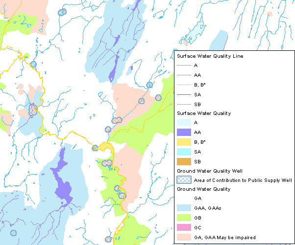
Water Quality Classifications have been assigned to all surface and ground waters throughout the state. The Classifications, based on the adopted Water Quality Standards, establish designated uses for surface and ground waters and identify the criteria necessary to support those uses. The Surface Water Quality Classifications and the Ground Water Quality Classifications are usually presented together as a complete depiction of Water Quality Classifications in Connecticut. This edition of the Water Quality Classifications is based on the Water Quality Standards adopted on February 25, 2011.
Surface water refers to rivers and streams, brooks, waterways, lakes, ponds, marshes, swamps, bogs, federal jurisdictional wetlands; the waters of Long Island Sound, its harbors, embayments, tidal wetlands and creeks; and other natural or artificial, public or private, vernal or intermittent bodies of water, excluding groundwater. Ground water refers to water flowing through earth materials beneath the ground surface, excluding surface waters.
There are three classes for inland surface waters (AA, A, and B), two classes for coastal/marine surface waters (SA and SB), and four classes for ground water (GAA, GA, GB, and GC). The Connecticut Water Quality Standards and Classifications (WQS) describe these classes and also establish the overall policy and management structure to protect the water quality of Connecticut. The classification designate the uses for each waterbody and the ground water. For example, the following uses are designated for a Class A waterbody: potential drinking water supply, fish and wildlife habitat, recreational use, agricultural and industrial supply, and navigation. Both the surface water and ground water classifications data were originally compiled in 1980 from information collected for each major drainage basin. The water quality clssifications are updated on a rotating schedule by major drainage basin. The ground water quality classifications maybe changed after the adoption date under specific circumstances.
The management of water quality in Connecticut is guided by Section 22a-426 of the Connecticut General Statutes. To implement these policies, identification and mapping of the Water Quality Classifications is essential. The data included here are intended to be used to show ground and surface water quality classifications in Connecticut at 1:24,000 scale (1 inch = 2,000 feet), which is the map scale of a conventional 7.5 minute USGS topographic quadrangle map. Other GIS data such as USGS topographic quadrangle map imagery, orthophotography, hydrography, drainage basins, street centerlines, railroads, and political boundaries are useful background reference data to display with the water quality classifications. It is often useful to display Aquifer Protection Areas with water quality classifications.
7.5 minute USGS topographic quadrangle maps published at 1:24,000 scale were the primary map base used to compile and map surface and ground water quality classifications statewide. Consequently, the horizontal positional accuracy of the surface and ground water quality classifications is consistent with and is best used with other 1:24,000-scale data such as Connecticut Hydrography, Connecticut Waterbody, Connecticut Named Waterbody, Connecticut Town Boundaries, and Connecticut Subregional Drainage Basins. Overlaying surface and ground water quality classifications onto information that is more horizontally accurate and current than the USGS topographic quadrangle maps such as Connecticut 2004 Orthophotography may result in location differences and inaccuracies. For example, the location and shape of rivers and streams depicted in the surface water quality classification data may not exactly match information shown in the aerial photography primarily due to differences in spatial accuracy and data collection dates between the two datasets.
Status - Infrequent updates.
Date of Surface Water Quality Class Data- Refer to the Citation Edition Date in Surface Water Quality Classifications GIS Metadata
Date of Ground Water Quality Class Data - Refer to the Citation Edition Date in Ground Water Quality Classification GIS Metadata
Map Scale and Accuracy - 1:24,000 (1 inch = 2000 feet)
Water Quality Classifications - CT ECO Complete Resource Guide
Surface Water Quality Classification Line Feature GIS Metadata – Contains technical documentation describing the Surface Water Quality Classification Line feature data and the data sources, process steps, and standards used to collect, digitize, and store this information in a geographic information system (GIS).
Surface Water Quality Classification Polygon Feature GIS Metadata – Contains technical documentation describing the Surface Water Quality Classification Polygon feature data and the data sources, process steps, and standards used to collect, digitize, and store this information in a geographic information system (GIS).
Ground Water Quality Classification Polygon Feature GIS Metadata– Contains technical documentation describing the Ground Water Quality Classification Polygon feature data and the data sources, process steps, and standards used to collect, digitize, and store this information in a geographic information system (GIS).
Connecticut Department of Energy and Environmental Protection Water Home Page
Connecticut Department of Energy and Environmental Protection Water Quality Home Page
Water Quality Classification data is downloadable from DEEP GIS Data.
Connect GIS and AutoCAD software to this information online using the Water Resource Management CT ECO Map Service.