Connecticut Environmental Conditions Online

Map Catalog - Quadrangles

The Map Catalog includes a variety of maps in PDF format that require Adobe Reader Adobe Reader icon to view. Full-size printed copies are available from the DEEP Store. Refer to Connecticut Digital Orthophotography for a list and brief description of orthophotography available in CT ECO.

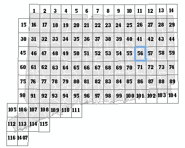
Click on the menu or the map to select a quadrangle.


Willimantic, 56


FAQ

Oxford, 14 Webster, 13 Southbridge, 12 Bashbish Falls, 1 Wales, 11 Ashley Falls, 2 Monson, 10 South Sandisfield, 3 Hampden, 9 Tolland Center, 4 Springfield South, 8 West Granville, 5 West Springfield, 7 Southwick, 6 Thompson, 29 Putnam, 28 Millerton, 15 Eastford, 27 Sharon, 16 Westford, 26 South Canaan, 17 Stafford Springs, 25 Norfolk, 18 Ellington, 24 Winsted, 19 Broad Brook, 23 New Hartford, 20 Windsor Locks, 22 Tariffville, 21 East Killingly, 44 Danielson, 43 Amenia, 30 Hampton, 42 Ellsworth, 31 Spring Hill, 41 Cornwall, 32 Coventry, 40 West Torrington, 33 Rockville, 39 Torrington, 34 Manchester, 38 Collinsville, 35 Hartford North, 37 Avon, 36 Oneco, 59 Plainfield, 58 Dover Plains, 45 Scotland, 57 Kent, 46 Willimantic, 56 New Preston, 47 Columbia, 55 Litchfield, 48 Marlborough, 54 Thomaston, 49 Glastonbury, 53 Bristol, 50 Hartford South, 52 New Britain, 51 Voluntown, 74 Jewett City, 73 Pawling, 60 Norwich, 72 New Milford, 61 Fitchville, 71 Roxbury, 62 Colchester, 70 Woodbury, 63 Moodus, 69 Waterbury, 64 Middle Haddam, 68 Southington, 65 Middletown, 67 Meriden, 66 Ashaway, 89 Old Mystic, 88 Brewster, 75 Uncasville, 87 Danbury, 76 Montville, 86 Newtown, 77 Hamburg, 85 Southbury, 78 Deep River, 84 Naugatuck, 79 Haddam, 83 Mount Carmel, 80 Durham, 82 Wallingford, 81 Watch Hill, 104 Mystic, 103 Peach Lake, 90 New London, 102 Bethel, 91 Niantic, 101 Botsford, 92 Old Lyme, 100 Long Hill, 93 Essex, 99 Ansonia, 94 Clinton, 98 New Haven, 95 Guilford, 97 Branford, 96 Mount Kisco, 105 Pound Ridge, 106 Norwalk North, 107 Westport, 108 Bridgeport, 109 Milford, 110 Woodmont, 111 Glenville, 112 Stamford, 113 Norwalk South, 114 Sherwood Point, 115 Mamaroneck, 116 Bayville NY, 1407 Map
Map Name
Map Info
Scale
Size
Last Updated
File Size

Quarter Quad Soil Survey (Northeast Quad)

Data Guide

1:12,000

22 x 27

.31 - 1.1 Mb

Quarter Quad Soil Survey (Northwest Quad)

Data Guide

1:12,000

22 x 27

.31 - 1.1 Mb

Quarter Quad Soil Survey (Southeast Quad)

Data Guide

1:12,000

22 x 27

.31 - 1.1 Mb

Quarter Quad Soil Survey (Southwest Quad)

Data Guide

1:12,000

22 x 27

.31 - 1.1 Mb

Quaternary Geology

Data Guide

1:24,000

34 x 30

12/8/2010

0.85 -27.6 Mb

Surficial Materials

Data Guide

1:24,000

48 x 36

8/25/2009

2.7 - 11.4 Mb


State of Connecticut

FAQ

Map Name
Map Info
Scale
Size
Last Updated
File Size

Aquifer Protection Area Large

Data Guide

1:150,000

48 x 36

12/23/2021

5.7 Mb


Aquifer Protection Area Small

Data Guide

to fit

11 x 8.5

12/23/2021

4 Kb


Bedrock Geology Map (1985)

None

1:125,000

55 x 42

26.6 Mb


Bedrock Mines and Quarries Map (1987)

None

1:125,000

55 x 42

16.9 Mb


Groundwater Availability Map (1978)

None

1:125,000

56 x 42.1

15.3 Mb


Groundwater Yield Map (1986)

None

1:125,000

56 x 42.1

11.9 Mb


Natural Drainage Basins Map - small (1981)

None

1:125,000

30 x 22

4.2 Mb


Natural Drainage Basins Map (1981)

None

1:250,000

58 x 42

17.4 Mb


Planimetric Map (1965, revised 1974)

None

1:125,000

56 x 42

11.8 Mb


Quaternary Geologic Map (2005)

None

1:125,000

66 x 46

54.4 Mb


Radar Image Map (1984)

None

1:250,000

34 x 28

19.6 Mb


Sand and Gravel Resources Map (1993)

None

1:250,000

36 x 24.5

4.3 Mb


Shaded Relief Map (1965, revised 1974)

None

1:125,000

56 x 42

13.9 Mb


Surficial Aquifer Potential Map (2008)

None

1:150,000

48 x 36

22.4 Mb


Surficial Materials Map (1992)

None

1:125,000

54 x 42.1

26.5 Mb


Topographic and Woodland Map (1965, revised 1974)

None

1:125,000

56 x 42.1

17.0 Mb


Topographic Map (1965, revised 1974)

None

1:125,000

56 x 42.1

17.1 Mb