Connecticut Environmental Conditions Online

Map Catalog

The Map Catalog includes a variety of maps in PDF format that require Adobe Reader Adobe Reader icon to view. Full-size printed copies are available from the DEEP Store. Refer to Connecticut Digital Orthophotography for a list and brief description of orthophotography available in CT ECO.

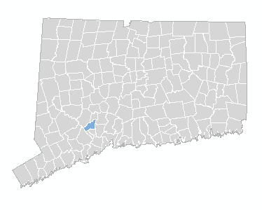
Click on the menu or the map to select a town.


Seymour


FAQ

Map Andover Ansonia Ashford Avon Barkhamsted Beacon Falls Berlin Bethany Bethel Bethlehem Bloomfield Bolton Bozrah Branford Bridgeport Bridgewater Bristol Brookfield Brooklyn Burlington Canaan Canterbury Canton Chaplin Cheshire Chester Clinton Colchester Colebrook Columbia Cornwall Coventry Cromwell Danbury Darien Deep River Derby Durham Eastford East Granby East Haddam East Hampton East Hartford East Haven East Lyme Easton East Windsor Ellington Enfield Essex Fairfield Farmington Franklin Glastonbury Goshen Granby Greenwich Griswold Groton Guilford Haddam Hamden Hampton Hartford Hartland Harwinton Hebron Kent Killingly Killingworth Lebanon Ledyard Lisbon Litchfield Lyme Madison Manchester Mansfield Marlborough Meriden Middlebury Middlefield Middletown Milford Monroe Montville Morris Naugatuck New Britain New Canaan New Fairfield New Hartford New Haven Newington New London New Milford Newtown Norfolk North Branford North Canaan North Haven North Stonington Norwalk Norwich Old Lyme Old Saybrook Orange Oxford Plainfield Plainville Plymouth Pomfret Portland Preston Prospect Putnam Redding Ridgefield Rocky Hill Roxbury Salem Salisbury Scotland Seymour Sharon Shelton Sherman Simsbury Somers Southbury Southington South Windsor Sprague Stafford Stamford Sterling Stonington Stratford Suffield Thomaston Thompson Tolland Torrington Trumbull Union Vernon Voluntown Wallingford Warren Washington Waterbury Waterford Watertown Westbrook West Hartford West Haven Weston Westport Wethersfield Willington Wilton Winchester Windham Windsor Windsor Locks Wolcott Woodbridge Woodbury Woodstock
Map Name
Map Info
Scale
Size
Last Updated
File Size

Aquifer Protection Area

Data Guide

varies

11 x 8.5

12/23/2021

0.4 - 1.2 Mb

Aquifer Protection Area

Data Guide

1:24,000

48 x 36

12/23/2021

1.7 - 6.0 Mb

Contour Map

Data Guide

varies

34 x 30

5/19/2011

1.3 - 4.8 Mb

DEEP Property

Data Guide

1:24,000

48 x 36

7/31/2014

1.7 - 2.3 Mb

Natural Diversity Data Base Areas

Data Guide

1:24,000

48 x 36

12/18/2023

1.2 - 3.2 Mb

Natural Diversity Data Base Areas (Small)

Data Guide

varies

8.5 x 11

12/18/2023

3.0 - 11.0 Mb

Natural Drainage Basin With Contours

Data Guide

1:24,000

48 x 36

5/19/2011

6.1 - 10.7 Mb

Natural Drainage Basin With Shaded Relief

Data Guide

1:24,000

48 x 36

1/19/2010

2.9 - 6 Mb

Orthophoto 1990

Data Guide

varies

34 x 30

12/20/2010

6.1 - 13.2 Mb

Orthophoto 2004

Data Guide

varies

34 x 30

12/20/2010

4.2 - 11.1 Mb

Orthophoto 2006

Data Guide

varies

34 x 30

12/20/2010

7.3 - 14.2 Mb

Orthophoto 2008

Data Guide

varies

34 x 30

12/20/2010

8.4 - 15.0 Mb

Orthophoto 2008 - Infrared

Data Guide

varies

34 x 30

12/20/2010

8.5 - 16.9 Mb

Orthophoto 2008 - Leaf Off

Data Guide

varies

34 x 30

12/20/2010

6.0 - 13.6 Mb

Orthophoto 2010

Data Guide

varies

34 x 30

1/20/2011

8.1 - 14.4 Mb

Orthophoto 2010 - Infrared

Data Guide

varies

34 x 30

1/20/2011

9.6 - 17.6 Mb

Orthophoto 2012

None

to fit

34 x 30

1/31/2013

3.9 - 7.5 Mb

Orthophoto 2012 Infrared

None

to fit

34 x 30

1/31/2013

3.8 - 7.6 Mb

Orthophoto 2012 Leaf Off

None

to fit

34 x 30

2/28/2013

2.0 - 5.4 MB

Orthophoto 2012 Leaf Off Infrared

None

to fit

34 x 30

2/28/2013

2.2 - 5.7 MB

Protected Open Space Mapping

Data Guide

Varies

48 x 36

8/31/2011

0.8 - 3.9 Mb

Q3 Flood Zone Map

None

varies

34 x 30

5/19/2011

21.2 - 37.0 Mb

Quaternary Geology

Data Guide

1:24,000

48 x 36

12/8/2010

11.8 - 63.7

Soil

Data Guide

1:24,000

48 x 36

11/5/2009

6.4 - 16.7 Mb

Soil Drainage Class

Data Guide

1:24,000

48 x 36

4/6/2010

3.2 - 9.0 Mb

Soil Farmland

Data Guide

1:24,000

48 x 36

4/6/2011

1.7 - 7.3 Mb

Soil Flooding Class

Data Guide

1:24,000

48 x 36

4/6/2010

7.2 - 51.4 Mb

Soil Hydric

Data Guide

1:24,000

48 x 36

10/28/2009

1.7 - 6.0 Mb

Soil Inland Wetland

Data Guide

1:24,000

48 x 36

10/28/2009

1.8 - 6.1 Mb

Soil Parent Material

Data Guide

1:24,000

48 x 36

11/17/2009

3.2 - 9.4 Mb

Soil Subsurface Sewage Disposal Potential

Data Guide

1:24,000

48 x 36

10/28/2009

3.2 - 9.4 Mb

Street Map

Data Guide

varies

34 x 30

8/20/2010

4.5 - 30.3 Mb

Surficial Materials

Data Guide

1:24,000

48 x 36

8/25/2009

6.7 - 39.8 Mb

Water Quality Classifications

Data Guide

1:24,000

48 x 36

10/31/2018

1.0 - 3.4 Mb

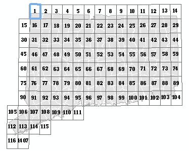
Click on the menu or the map to select a quadrangle.


Bashbish Falls, 1


FAQ

Oxford, 14 Webster, 13 Southbridge, 12 Bashbish Falls, 1 Wales, 11 Ashley Falls, 2 Monson, 10 South Sandisfield, 3 Hampden, 9 Tolland Center, 4 Springfield South, 8 West Granville, 5 West Springfield, 7 Southwick, 6 Thompson, 29 Putnam, 28 Millerton, 15 Eastford, 27 Sharon, 16 Westford, 26 South Canaan, 17 Stafford Springs, 25 Norfolk, 18 Ellington, 24 Winsted, 19 Broad Brook, 23 New Hartford, 20 Windsor Locks, 22 Tariffville, 21 East Killingly, 44 Danielson, 43 Amenia, 30 Hampton, 42 Ellsworth, 31 Spring Hill, 41 Cornwall, 32 Coventry, 40 West Torrington, 33 Rockville, 39 Torrington, 34 Manchester, 38 Collinsville, 35 Hartford North, 37 Avon, 36 Oneco, 59 Plainfield, 58 Dover Plains, 45 Scotland, 57 Kent, 46 Willimantic, 56 New Preston, 47 Columbia, 55 Litchfield, 48 Marlborough, 54 Thomaston, 49 Glastonbury, 53 Bristol, 50 Hartford South, 52 New Britain, 51 Voluntown, 74 Jewett City, 73 Pawling, 60 Norwich, 72 New Milford, 61 Fitchville, 71 Roxbury, 62 Colchester, 70 Woodbury, 63 Moodus, 69 Waterbury, 64 Middle Haddam, 68 Southington, 65 Middletown, 67 Meriden, 66 Ashaway, 89 Old Mystic, 88 Brewster, 75 Uncasville, 87 Danbury, 76 Montville, 86 Newtown, 77 Hamburg, 85 Southbury, 78 Deep River, 84 Naugatuck, 79 Haddam, 83 Mount Carmel, 80 Durham, 82 Wallingford, 81 Watch Hill, 104 Mystic, 103 Peach Lake, 90 New London, 102 Bethel, 91 Niantic, 101 Botsford, 92 Old Lyme, 100 Long Hill, 93 Essex, 99 Ansonia, 94 Clinton, 98 New Haven, 95 Guilford, 97 Branford, 96 Mount Kisco, 105 Pound Ridge, 106 Norwalk North, 107 Westport, 108 Bridgeport, 109 Milford, 110 Woodmont, 111 Glenville, 112 Stamford, 113 Norwalk South, 114 Sherwood Point, 115 Mamaroneck, 116 Bayville NY, 1407 Map
Map Name
Map Info
Scale
Size
Last Updated
File Size

Quarter Quad Soil Survey (Southeast Quad)

Data Guide

1:12,000

22 x 27

.31 - 1.1 Mb

Quarter Quad Soil Survey (Southwest Quad)

Data Guide

1:12,000

22 x 27

.31 - 1.1 Mb

Quaternary Geology

Data Guide

1:24,000

34 x 30

12/8/2010

0.85 -27.6 Mb

Surficial Materials

Data Guide

1:24,000

48 x 36

8/25/2009

2.7 - 11.4 Mb


State of Connecticut

FAQ

Map Name
Map Info
Scale
Size
Last Updated
File Size

Aquifer Protection Area Large

Data Guide

1:150,000

48 x 36

12/23/2021

5.7 Mb


Aquifer Protection Area Small

Data Guide

to fit

11 x 8.5

12/23/2021

4 Kb


Bedrock Geology Map (1985)

None

1:125,000

55 x 42

26.6 Mb


Bedrock Mines and Quarries Map (1987)

None

1:125,000

55 x 42

16.9 Mb


Groundwater Availability Map (1978)

None

1:125,000

56 x 42.1

15.3 Mb


Groundwater Yield Map (1986)

None

1:125,000

56 x 42.1

11.9 Mb


Natural Drainage Basins Map - small (1981)

None

1:125,000

30 x 22

4.2 Mb


Natural Drainage Basins Map (1981)

None

1:250,000

58 x 42

17.4 Mb


Planimetric Map (1965, revised 1974)

None

1:125,000

56 x 42

11.8 Mb


Quaternary Geologic Map (2005)

None

1:125,000

66 x 46

54.4 Mb


Radar Image Map (1984)

None

1:250,000

34 x 28

19.6 Mb


Sand and Gravel Resources Map (1993)

None

1:250,000

36 x 24.5

4.3 Mb


Shaded Relief Map (1965, revised 1974)

None

1:125,000

56 x 42

13.9 Mb


Surficial Aquifer Potential Map (2008)

None

1:150,000

48 x 36

22.4 Mb


Surficial Materials Map (1992)

None

1:125,000

54 x 42.1

26.5 Mb


Topographic and Woodland Map (1965, revised 1974)

None

1:125,000

56 x 42.1

17.0 Mb


Topographic Map (1965, revised 1974)

None

1:125,000

56 x 42.1

17.1 Mb